The length of Russian borders is more than 60.9 thousand kilometers, which are guarded by approximately 183 thousand border guards. Russia borders on 16 countries.
The length of Russian borders is more than 60.9 thousand kilometers, which are guarded by approximately 183 thousand border guards. Modern borders Russia and the former Soviet republics are not fully formalized in international legal terms. For example, the border between the Russian Federation and the Republic of Ukraine has still not been demarcated, although the delimitation of the land border was completed last year.
Russia borders on 16 countries. The length of the border with Norway is 219.1 kilometers, with Finland - 1325.8 kilometers, with Estonia - 466.8 kilometers, with Latvia - 270.5 kilometers, with Lithuania (border with the Kaliningrad region) - 288.4 kilometers, with Poland (border with the Kaliningrad region) - 236.3 kilometers, with Belarus - 1239 kilometers, with Ukraine - 2245.8 kilometers, with Georgia - 897.9 kilometers, with Azerbaijan - 350 kilometers, with Kazakhstan - 7,598.6 kilometers, with Mongolia - 3,485 kilometers, with China - 4,209.3 kilometers, with the DPRK - 39.4 kilometers, with Japan - 194.3 kilometers, with the USA - 49 kilometers.
Land borders
On land, Russia borders on 14 states, 8 of which are former Soviet republics.
The length of the land border with Norway is 195.8 kilometers (of which 152.8 kilometers are the border passing along rivers and lakes), with Finland - 1271.8 kilometers (180.1 kilometers), with Poland (border with the Kaliningrad region) - 204.1 kilometers (0.8 kilometers), with Mongolia - 3,485 kilometers, with China - 4,209.3 kilometers, with the DPRK - 17 kilometers along rivers and lakes, with Estonia - 324.8 kilometers (235.3 kilometers) , with Latvia - 270.5 kilometers (133.3 kilometers), with Lithuania (border with the Kaliningrad region) - 266 kilometers (236.1 kilometers), with Belarus - 1239 kilometers, with Ukraine - 1925.8 kilometers (425.6 kilometers), with Georgia - 875.9 kilometers (56.1 kilometers), with Azerbaijan - 327.6 kilometers (55.2 kilometers), with Kazakhstan - 7,512.8 kilometers (1,576.7 kilometers).
The Kaliningrad region is a semi-enclave: the territory of a state, surrounded on all sides by the land borders of other states and having access to the sea.
Western land borders not tied to any natural boundaries. In the section from the Baltic to the Azov Sea, they pass through populated and developed lowland territories. Here the border is crossed by railways: St. Petersburg-Tallinn, Moscow-Riga, Moscow-Minsk-Warsaw, Moscow-Kyiv, Moscow-Kharkov.
Russia's southern border with Georgia and Azerbaijan runs through the Caucasus Mountains from the Black Sea to the Caspian Sea. Railways are laid along the edge of the banks; two roads pass through the central part of the ridge, which are often closed in winter due to snow drifts.
The longest land border - with Kazakhstan - runs through the steppes of the Volga region, the Southern Urals and southern Siberia. The border is crossed by many railways connecting Russia not only with Kazakhstan, but also with the countries of Central Asia: Astrakhan-Guriev (further to Turkmenistan), Saratov-Uralsk, Orenburg-Tashkent, Barnaul-Alma-Ata, a small section of the Trans-Siberian Railway Chelyabinsk-Omsk, Central Siberian and South Siberian Railways.
The second longest border with China runs along the channel of the Amur River, its tributary the Ussuri River, and the Argun River. It is crossed by the Chinese Eastern Railway (CER), built back in 1903, and the Chita-Vladivostok highway, laid through Chinese territory to connect the Far East and Siberia by the shortest route.
The border with Mongolia passes through the mountainous regions of Southern Siberia. The Mongolian border is crossed by a branch of the Trans-Siberian Railway - Ulan-Ude-Ulaanbaatar-Beijing.
Passes across the border with the DPRK railway to Pyongyang.
Maritime boundaries
By sea, Russia borders on 12 countries. The length of the maritime border with Norway is 23.3 kilometers, with Finland - 54 kilometers, with Estonia - 142 kilometers, with Lithuania (border with the Kaliningrad region) - 22.4 kilometers, with Poland (border with the Kaliningrad region) - 32.2 kilometers, with Ukraine - 320 kilometers, with Georgia - 22.4 kilometers, with Azerbaijan - 22.4 kilometers, with Kazakhstan - 85.8 kilometers, with the DPRK - 22.1 kilometers.
Russia only has a maritime border with the United States and Japan. These are narrow straits that separate the Southern Kuril Islands from the island of Hokkaido and Ratmanov Island from Kruzenshtern Island. The length of the border with Japan is 194.3 kilometers, with the USA - 49 kilometers.
The longest maritime border (19,724.1 kilometers) runs along the coast of the Arctic Ocean seas: Barents, Kara, Laptev, East Siberian and Chukotka. Year-round navigation without icebreakers is possible only off the northern shores of the Kola Peninsula. All northern ports except Murmansk operate only during short northern navigation: 2–3 months. Therefore, the northern sea border does not have of great importance for connections with other countries.
The second longest maritime border (16,997 kilometers) runs along the coast of the Pacific Ocean: Bering, Okhotsk, and Japanese. The southeastern coast of Kamchatka goes directly to the ocean. The main ice-free ports are Vladivostok and Nakhodka.
Railways reach the coast only in the south of Primorsky Krai in the port area and in the Tatar Strait (Sovetskaya Gavan and Vanino). The coastal areas of the Pacific coast are poorly developed and populated.
The length of the sea coast of the Baltic and Azov-Black Sea basins is small (126.1 kilometers and 389.5 kilometers, respectively), but is used with greater intensity than the coasts of the northern and eastern borders.
In the USSR, large ports were mainly built in the Baltic region. Now Russia can use their capacity only for a fee. The country's largest maritime merchant fleet is St. Petersburg; new ports and oil terminals are being built in the Gulf of Finland.
In the Sea of Azov, the maritime border runs from the Taganrog Bay to the Kerch Strait, and then along the Black Sea coast of the Caucasus. The main ports of the Black Sea coast are Novorossiysk (the largest port in Russia) and Tuapse. The Azov ports - Yeysk, Taganrog, Azov - are shallow and inaccessible to large ships. In addition, the Azov coast freezes for a short time and navigation here is supported by icebreakers.
The maritime border of the Caspian Sea is not precisely defined and is estimated by Russian border guards at 580 kilometers.
Cross-border populations and cooperation
Representatives of almost 50 nationalities live in the border regions of Russia and neighboring states. Of the 89 constituent entities of the Russian Federation, 45 represent border regions of the country. They occupy 76.6 percent of the entire territory of the country. They are home to 31.6 percent of the Russian population. The population of the border areas is 100 thousand people (as of 1993).
Cross-border cooperation is usually understood as a state-public structure, which includes Federal departments, authorities state power subjects of the Russian Federation, authorities local government, population activities, public initiatives. Both old border regions and new ones are interested in developing cross-border cooperation. In the latter, problems periodically arise related to the sudden severance of established ties between neighboring regions. In a number of cases, the border “breaks” the resource (water, energy, information, etc.) communications of economic objects (for example, the energy dependence of the Omsk region on Kazakhstan). On the other hand, in new border regions the flow of goods is constantly increasing, which can bring many benefits, subject to large investments in the appropriate infrastructure.
Thus, the border regions of states need joint socio-economic development, sharing sources of resources, establishing information infrastructure and restoring communications between the population.
The basis for the successful development of cross-border cooperation is good neighborly relations between the parties at the state level, developed legislative framework(framework agreements on cooperation, legislative regulation of customs rules, abolition of the practice of double taxation, simplification of the procedure for moving goods) and the desire of the regions to participate in the development of cooperation.
Problems of cooperation in border areas
Despite the imperfection of Russian federal legislation regarding cross-border cooperation of its regions, at the level of municipal and local self-government, it is, one way or another, implemented in all 45 border regions.
Unestablished good neighborly relations with the Baltic countries do not provide opportunities for the widespread development of cross-border cooperation at the regional level, although its need is acutely felt by the population of border areas.
Today, on the border with Estonia, a simplified border crossing procedure is used for border residents. But from January 1, 2004, Estonia intends to switch to the strict visa regime established by the Schengen Agreement. Latvia abandoned the simplified procedure back in March 2001.
As for regional cooperation, back in July 1996, the Council for Cooperation of Border Regions was created in Põlva (Estonia), which included representatives of the Võru and Põlva counties of Estonia, the Aluksnensky and Balvi districts of Latvia, as well as the Palkinsky, Pechersky and Pskov districts of the Pskov region. The main objectives of the Council are to develop a joint strategy for cross-border cooperation and implement projects in matters of improving infrastructure and security environment. More than two hundred enterprises with the participation of Estonian and Latvian capital operate in the Pskov region.
Starting next year, Lithuania will introduce visas for Russian citizens transiting through its territory. This decision affects the interests of residents of the Russian semi-enclave, the Kaliningrad region. Economic problems the region may also arise due to the introduction of a visa regime by Poland. The authorities of the Kaliningrad region pin high hopes for solving visa issues on the European Framework Convention on Transfrontier Cooperation between Territorial Communities and Authorities, which has just been ratified by Russia.
On a contractual basis, the Kaliningrad region interacts with seven voivodeships of Poland, four counties of Lithuania and the district of Bornholm (Denmark). In 1998, the region joined multilateral cross-border cooperation within the framework of the Baltic Euroregion, and three of its municipalities- to work on the creation of the Euroregion “Saule” (with the participation of Lithuania and Latvia). In the second half of the 90s, a number of agreements were signed on interregional cooperation between the Kaliningrad region and the Klaipeda, Panevezys, Kaunas, and Marijampole counties of Lithuania.
Changes are being planned in relations at the state level between Ukraine and Russia. The Government of the Russian Federation approved the draft Program of Interregional and Cross-Border Cooperation between the Russian Federation and Ukraine for 2001–2007. At the regional level, it is actively carried out in the Krasnodar Territory and the Rostov Region.
Quite tense relations have developed in the Caucasus region of Russia and Georgia. In 2000, restrictions on movement between Georgia and Russia were introduced, which significantly affected the residents of both republics of Ossetia. Today, at the regional level, the regions of North Ossetia have established border connections with the Kazbek region of Georgia; since August 2001, their residents can cross the border without obtaining visas.
The situation on the Dagestan section of the border is better: in 1998, through the efforts of the Dagestan government, restrictions on crossing the Russian state border with Azerbaijan were lifted, which helped reduce tensions and intensify economic ties. In pursuance of the intergovernmental agreement on trade and economic cooperation between Dagestan and Azerbaijan, an industry agreement has been prepared - on cooperation in the agro-industrial complex.
The expansion of cooperation between neighboring regions of Kazakhstan and Russia is associated with the issues of completing the processes of delimitation and demarcation of borders. For example, the Altai Territory actively cooperates with China, Mongolia and the Central Asian republics of the CIS (Kazakhstan, Uzbekistan, Kyrgyzstan and Tajikistan). The main partners in cross-border cooperation of the Altai Territory are the East Kazakhstan and Pavlodar regions of the Republic of Kazakhstan. The volume of foreign trade turnover between Altai and Kazakhstan is about a third of the region’s total foreign trade turnover. As a necessary legal basis for the development of this kind of cross-border cooperation, Russia is considering bilateral Cooperation Agreements between the regional administration and the regions of Kazakhstan.
The nature of border relations between the Russian Federation and Mongolia is determined by the underdevelopment of the western aimags of Mongolia. Trade with Mongolia is dominated by small contracts. Promising direction in cross-border cooperation between Russia and Mongolia - the development of ore deposits explored in the west of the country. If direct transport communication projects are implemented, the possible construction of a gas pipeline between Russia and China through Mongolia will create the necessary energy and infrastructure conditions for the participation of Siberian regions in the development of Mongolia's raw materials. A milestone in the development of relations was the opening of the Consulate General of Mongolia in Kyzyl in February 2002.
Cross-border cooperation between the regions of Russia and Japan is influenced by the Japanese side’s interest in the islands of the South Kuril chain. In 2000, the “Program of Japanese-Russian cooperation in the field of development of joint economic activity on the islands of Iturup, Kunashir, Shikotan and Habomai."
Former residents of the islands and members of their families - Japanese citizens - can visit the islands under a simplified visa regime. For many years, there have been visa-free exchanges between the parties. The Ministry of Foreign Affairs of Japan organizes Japanese language courses.
Objective difficulties are associated with the fact that the Japanese do not recognize the islands as Russian. The Japanese side's assistance in the construction of power plants and clinics can be viewed as an act of goodwill, and not as cooperation of equal parties.
The most active in the development of cooperation are the northwestern and southeastern directions - the “old” border regions.
Cooperation in the Russian-Finnish border region
The Murmansk and Leningrad regions, the Republic of Karelia are participants in cross-border cooperation with the regions of the Finnish side. There are several cooperation programs: the Nordic Council of Ministers program, the Interreg program and the Northern Dimension. The fundamental documents are Treaties on the Establishment of Friendly Relations between Regions and bilateral cooperation plans.
In 1998, at the international seminar “External borders of the EU - soft borders” in Joensuu (Finland), the government of the Republic of Karelia proposed creating the Euroregion “Karelia”. The idea was supported by the leaders of border regional unions and approved at top level both states in the same year.
The goal of the project is to create a new model of cross-border cooperation between regional unions of Finland and the Republic of Karelia. The task is to remove barriers that exist in cooperation between territories, first of all, to develop communication between residents of adjacent regions.
In the structure of the economy of the Euroregion "Karelia", the main industry is the service sector, both in the territory of the Finnish regional unions and in the Republic of Karelia (at least two thirds of the working population are employed in this area). The second largest industries are industry and construction, followed by agriculture and forestry.
The weaknesses of the Russian part of the region, which can negatively affect cooperation and must certainly be taken into account in close cooperation with the Finnish side, are the raw material orientation of the industry, poor development of communications, local environmental problems and low level life.
In October 2000, Karelia adopted the “Cross-border Cooperation Program of the Republic of Karelia for 2001–2006.” The Government of Finland approved and sent to the EU the Interreg-III A-Karelia Program on the territory of Finland. At the same time, in 2000, the general Program of Action for 2001–2006 and the work plan for next year, according to which 9 priority projects are identified for implementation. These include the construction of an international automobile checkpoint, the development of scientific cooperation, and the development of the border territories of White Sea Karelia.
In January 2001, the activities of the Euroregion received support through the EU Tacis program - the European Commission allocated 160 thousand euros for the Euroregion Karelia project.
There is a simplified visa regime at the Russian-Finnish border.
Cooperation in the Russian-Chinese border region
Cross-border cooperation on the Russian-Chinese section of the border has a centuries-old history.
The legal basis for interregional relations is the Agreement signed on November 10, 1997 between the governments of the Russian Federation and the People's Republic of China on the principles of cooperation between the constituent entities of Russia and the provinces, autonomous regions and cities of the central subordination of the People's Republic of China. The development of cross-border trade is facilitated by significant benefits provided by China to its participants (reduction of import tariffs by 50 percent).
In 1992, the State Council of the People's Republic of China declared four cities adjacent to Russia (Manchuria, Heihe, Suifenhe and Hunchun) “cities of cross-border cooperation.” Since that time, the Chinese side has been actively raising the issue of joint “free trade zones” on the border in the area of the main checkpoints.
In 1992, a simplified procedure for crossing the Chinese-Russian border was introduced.
At the end of November 1996, Chinese shopping complexes opened on the border, where Russian citizens are delivered with special passes (lists are compiled by the local administration).
To facilitate individual commercial activities residents of the border regions of Russia in February 1998, through an exchange of notes, a Russian-Chinese Agreement was concluded on the organization of simplified passage of Russian citizens to the Chinese parts of shopping complexes.
On January 1, 1999, the Regulations on new rules for regulating cross-border trade came into force, in particular, residents of border areas are allowed to import goods worth three thousand yuan into China duty-free (previously - one thousand).
Among the promising projects is the development of cooperation in the field of the timber industry, construction of infrastructure facilities, construction of pipeline networks for interstate projects, etc.
Cooperation between the border regions of Russia and China is also developing through the programs of UNIDO and UNDP. The most famous is the UNDP regional project for the development of economic cooperation in the Tumen River Basin (Tumen River Area Development Program) with the participation of Russia, China, North Korea, the Republic of Korea and Mongolia. The main areas of cooperation are the development of transport and telecommunications infrastructure.
The two largest banks of the parties, Vneshtorgbank of Russia and the Industrial and Commercial Bank of China, entered into an agreement on settlements for cross-border trade between the two countries. The agreement provides for the possibility of conducting bilateral settlements for cross-border trade within one day on the basis of mutually established credit lines.
At the state level, a policy of cultural rapprochement between neighboring countries is being pursued: the Consulate General of the People's Republic of China has been opened in Khabarovsk, Chinese is taught in secondary and higher educational institutions, festivals, scientific conferences, and bilateral meetings of regional authorities and economic partners are held.
The main problem in the region is the Russian side's fear of demographic pressure from the Chinese population. The population density of border areas on the Russian side is extremely low in absolute and relative values compared to the population density on the Chinese side.
From the history of relations between the border population. Russian-Chinese and Russian-Korean sections of the border.
Economic activity and trade on the border of China and the Russian Empire were regulated by the following basic documents:
Aigun Treaty - allowed mutual border trade between citizens of both states living along the Ussuri, Amur and Sungari rivers.
The Beijing Treaty allowed free and duty-free barter trade along the entire border line between citizens of Russia and China.
"Rules for overland trade between Russia and China", signed by government level in 1862 for 3 years and then confirmed in 1869, they established duty-free trade at a distance of 50 miles on both sides of the Russian-Chinese border.
The St. Petersburg Treaty of 1881 confirmed all the articles on the “Rules of Russian-Chinese trade in the Far East” that were recorded in previous treaties.
By the end of the 19th century, cross-border overland trade was the main form economic relations Russian population Far East and Manchuria. It played an extremely important role, especially in the initial period of development of the region. The first settlers needed the most essential items for personal and household use. The Cossacks received tobacco, tea, millet, and bread from Manchuria, selling, in turn, cloth and fabrics. The Chinese willingly purchased furs, dishes, and silver in coins and products.
The trade turnover of the Russian Far East with Manchuria in 1893–1895 amounted to 3 million rubles and was distributed accordingly among the regions: Amur - one million rubles, Primorsk - 1.5–2 million rubles, Transbaikal - no more than 0.1 million rubles.
The porto-free regime established in the border strip (duty-free trade regime), along with positive aspects contributed to the development of smuggling, which Chinese merchants widely used in their activities. Every year, gold is smuggled into Manchuria in late XIX century equaled 100 poods (which amounted to 1,344 thousand rubles). The cost of smuggling furs and other goods (except gold) was approximately 1.5–2 million rubles. And Chinese Hanshin vodka and opium were smuggled into the Far East from Manchuria. The main import into the Primorsky region came along the Sungari River. For example, in 1645, 4 thousand pounds of opium worth up to 800 thousand rubles were brought to the Primorsky region. Smuggling of alcohol from the Amur region to China in 1909–1910 was estimated at approximately 4 million rubles.
In 1913 Russian government extended the St. Petersburg Treaty (1881) for 10 years, excluding the article providing for duty-free trade within the 50-verst border strip.
In addition to cross-border trade, the Cossacks leased land shares to the Chinese and Koreans. There was mutual influence of the agricultural cultures of the Chinese, Koreans and Russians. The Cossacks learned to grow soybeans, melons, and corn. The Chinese used Cossack mills to grind grain. Another form of cooperation is the hiring of Chinese and Korean agricultural workers on Cossack farms, especially during seasonal periods of agricultural work. Relations between owners and workers were good; poor Chinese willingly took advantage of opportunities to earn money on Cossack farms. This also formed good neighborly relations on both sides of the border.
The Cossacks living on the border had strong, economically developed military, village and village economies, well-established economic, trade and cultural ties with the population of the adjacent territory, which had a positive effect on the general situation in the Russian-Chinese borderland and on the border itself. Many Ussuri and Amur Cossacks spoke Chinese well.
Good neighborly relations were manifested in the joint celebration of Russian, Orthodox and Chinese holidays. The Chinese came to visit their Cossack friends, the Cossacks went to celebrate the Chinese New Year. There were no particular problems with visiting friends on the adjacent side; the border in this regard was more conventional, all visits were under the control of the Cossack population and local authorities.
Of course, conflicts also arose at the local level. There are known cases of theft of livestock, hay, and use of hayfields by the other party. There were cases of Cossacks smuggling alcohol into neighboring territories and selling it through their friends. Disputes often arose over fishing on the Ussuri River and Lake Khanka. Conflicts were resolved by atamans and village boards or through the border commissioner of the South Ussuri Territory.
Russia is a huge state in terms of territory. The boundaries pass both by land and by sea. I would like to remember in detail who borders Russia, because our neighbors are many states.
Length
Russian border guards have a rather difficult job protecting state borders, because the total length of the country’s borders (don’t be surprised!) is more than 62 thousand kilometers. Note that the land border is shorter than the sea border, amounting to 24,625 km. The sea boundaries respectively stretched for 37,736 km.
Which countries does Russia border by sea?
So, let’s first consider the maritime border of our country, which is protected by the navy from intruders and saboteurs. In the north, the Russian border (with some exceptions) runs entirely through the waters of the Arctic Ocean and touches the Baltic Sea. Who does Russia border on in the north? You can sail from Arkhangelsk across the Barents Sea to the Norwegian island of Spitsbergen. The northern coast of Russia is also washed by the Kara, East Siberian, Chukchi seas, and the Laptev Sea. Navigation along them is very difficult, but this does not create any particular inconvenience in communication between countries, since only a formal border with the North Pole passes here.
The Baltic Sea, although relatively small, provides sea route from Russia to Sweden, Poland, the Baltic countries, Finland.

Maritime eastern border
In the east, unlike the northern borders, the seas do not freeze, so maritime trade with neighbors is very active. Who borders Russia on the Bering, Okhotsk and Japanese seas? Powerful economically developed states: USA and Japan. It is with these partners that maritime trade in this region mainly takes place. The length of the border with Japan is 149 kilometers, and with the United States only 49 kilometers. From the city of Yuzhno-Sakhalinsk you can sail to the port of Sapporo (Hokkaido Island, Japan) through the relatively small La Perouse Strait.

On this section of the border, Russia has a territorial conflict, that is, it is impossible to talk about a complete legally formed border. It's about about the fate of the Kuril Islands (Japan also claims them). This dispute has been going on since 1945, when the USSR defeated Japan in the Soviet-Japanese War. As such, a peace treaty was not concluded at the end of World War II, so this territorial issue has yet to be resolved.
Western land border of Russia
The states bordering Russia in the west are mainly former Soviet republics. The longest part of the border in this section is Ukrainian. We are talking about 2245 kilometers. On the Russian side, Ukraine is adjacent to the territories of the Bryansk, Kursk, Belgorod, Voronezh, Rostov regions, as well as the Krasnodar Territory. Which regions of Ukraine border on Russia? There are many such regions, namely: Lugansk, Kharkov, Sumy, Chernihiv and Kiev regions. In connection with the well-known events in the Donetsk and Lugansk regions, problems have arisen again, because control over the border with the Lugansk region of Ukraine has become more complicated.

The length of the border with Belarus is 2 times less than the Ukrainian section, and amounts to numerically 1239 kilometers. If we specify by region, then from the Russian side you can enter the territory of the union Belarus from the lands of the Bryansk, Tver, Pskov, Smolensk regions.
In the north-west there is a land border with Latvia (270 km) and Estonia (466 km). The uniqueness of this part is that you can get from the Kaliningrad region to the territory of other regions of Russia by land only through the countries of the Schengen zone (the Baltic countries already have a visa-free regime with Europe, since they are members of the EU).
Asia: who borders Russia by land?
Russia's only Asian land neighbors from Asia are states that are huge in size but different in population density: Mongolia and China. It is this part of the land border that is very long, because the junction with the territory of China lasts 4209 km, and with Mongolia - 3485 km.
You can enter China from the following regions of the Russian Federation: the Altai Republic, Chita, Amur, Khabarovsk regions, Jewish Autonomous Okrug and Primorsky Territory. If you are traveling to Russia from Mongolia, your route may run through the republics of Altai, Tyva, Buryatia, as well as through the Chita region.
Russia probably has the largest land border with Kazakhstan. This Republic has always been associated with the Asian world, but in lately This axiom has begun to be questioned because the national football team and club teams of this country take part in European cup tournaments. Therefore, the border with Kazakhstan is most likely European. By the way, the Russian Federation has very close relations with this state economic ties within the framework of the Customs Union, therefore the traffic of vehicles at checkpoints is very active.

But that's not all!
Which countries does Russia border on land in the north? It was said above that the northern part of Russia is mainly cold seas. But there are also land sections of the border with the Scandinavian countries. For example, the total boundary area with Finland is 1325 km, and with Norway - 219 km.
The southern neighbors of the Russian Federation are former components of the USSR: Georgia and Azerbaijan. Protecting the inviolability of Russian territory from encroachment from the lands of these states is problematic due to the geographical features of the mountainous terrain of the Caucasus.
In this article we looked at who borders Russia. Profitability geographical location our country on the world political map emphasize two points:
- The Russian Federation is located at the junction of two continents: Europe and Asia.
- There are common borders with more than 10 states.
Russian Federation is a huge country, ranking first in the world in terms of area. The states bordering Russia are located from all directions of the world, and the border itself reaches almost 61 thousand km.
Types of borders
The border of a state is the line that limits its actual area. Territory includes areas of land, water, underground minerals and airspace located within a country.
There are 3 types of borders in the Russian Federation: sea, land and lake (river). The sea border is the longest of all, it reaches about 39 thousand km. The land border is 14.5 thousand km long, and the lake (river) border is 7.7 thousand km long.
General information about all states bordering the Russian Federation
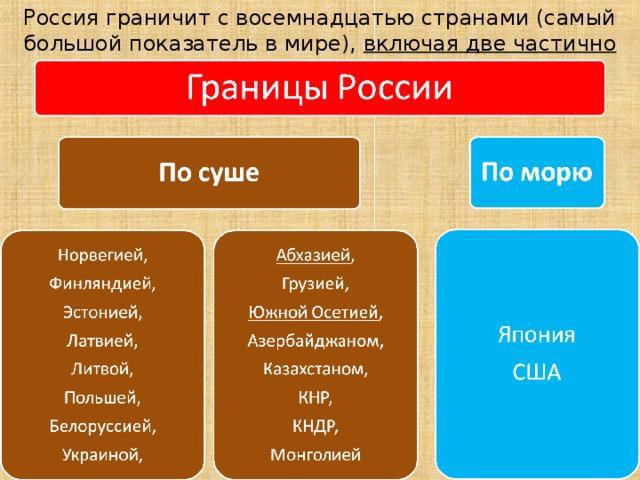
Which states does the Federation recognize its neighborhood with? 18 countries.
Name of states bordering Russia: South Ossetia, Republic of Belarus, Republic of Abkhazia, Ukraine, Poland, Finland, Estonia, Norway, Latvia, Lithuania, Kazakhstan, Georgia, Azerbaijan, United States of America, Japan, Mongolia, China First order countries are listed here .
Capitals of states bordering Russia: Tskhinvali, Minsk, Sukhum, Kyiv, Warsaw, Oslo, Helsinki, Tallinn, Vilnius, Riga, Astana, Tbilisi, Baku, Washington, Tokyo, Ulaanbaatar, Beijing, Pyongyang.
South Ossetia and the Republic of Abkhazia are partially recognized because not all countries in the world have recognized these countries as independent. Russia did this in relation to these states, therefore, it approved the neighborhood and borders with them.
Some states bordering Russia argue about the correctness of these borders. For the most part, disagreements arose after the end of the USSR.

Land borders of the Russian Federation
The states bordering Russia by land are located on the Eurasian continent. These also include lake (river) ones. Not all of them are currently protected; some of them can be crossed freely with only a passport of a citizen of the Russian Federation, which is not always necessarily checked.
States bordering Russia on the mainland: Norway, Finland, Belarus, South Ossetia, Ukraine, Republic of Abkhazia, Poland, Lithuania, Estonia, Kazakhstan, Latvia, Georgia, Azeybardzhan, Mongolia, People's Republic of China, North Korea.
Some of them also have a water border.
Available Russian territories which are surrounded on all sides foreign countries. Such areas include the Kaliningrad region, Medvezhye-Sankovo and Dubki.
You can travel to the Republic of Belarus without a passport and any border control along any of the possible roads.
Maritime borders of the Russian Federation
Which states does Russia border by sea? The sea border is considered to be a line 22 km or 12 nautical miles from the coast. The country's territory includes not only 22 km of water, but also all the islands in this sea area.
States bordering Russia by sea: Japan, the United States of America, Norway, Estonia, Finland, Poland, Lithuania, Abkhazia, Azerbaijan, Kazakhstan, Ukraine, North Korea. There are only 12 of them. The length of the borders is more than 38 thousand km. Russia has only a maritime border with the USA and Japan; there is no land boundary line with these countries. There are borders with other states both by water and by land.

Settled disputed sections of the border
At all times, there have been disputes between countries over territories. Some of the disputing countries have already agreed and are no longer raising this issue. These include: Latvia, Estonia, People's Republic of China and Azerbaijan.
The dispute between the Russian Federation and Azerbaijan occurred over a hydroelectric complex and water intake structures that belonged to Azerbaijan, but were in fact located in Russia. In 2010, the dispute was resolved, and the border was moved to the middle of this waterworks. Now the countries use the water resources of this hydroelectric complex in equal shares.
After the collapse of the USSR, Estonia considered it unfair that the right bank of the Narva River, Ivangorod and the Pechora region remained the property of Russia (Pskov region). In 2014, the countries signed an agreement on the absence of territorial claims. The border did not suffer any noticeable changes.

Latvia, like Estonia, began to lay claim to one of the districts of the Pskov region - Pytalovsky. An agreement with this state was signed in 2007. The territory remained the property of the Russian Federation, the border did not change.
The dispute between China and Russia ended with the demarcation of the border along the center of the Amur River, which led to the annexation of part of the disputed territories to the People's Republic of China. The Russian Federation transferred 337 square kilometers to its southern neighbor, including two plots in the Tarabarov region and one plot near Bolshoi Island. The signing of the agreement took place in 2005.
Unsettled disputed sections of the border
Some disputes over territory are not closed to this day. It is not yet known when the agreements will be signed. Russia has such disputes with Japan and Ukraine.
The Crimean Peninsula is a disputed territory between Ukraine and the Russian Federation. Ukraine considers the 2014 referendum illegal and Crimea occupied. The Russian Federation established its border unilaterally, while Ukraine passed a law creating a free economic zone on the peninsula.
The dispute between Russia and Japan is over the four Kuril Islands. The countries cannot come to a compromise because both believe that these islands should belong to them. These islands include Iturup, Kunashir, Shikotan and Habomai.
Boundaries of exclusive economic zones of the Russian Federation
An exclusive economic zone is a strip of water adjacent to the border of the territorial sea. It cannot be wider than 370 km. In this zone, the country has the right to develop subsoil resources, as well as to explore them and preserve them, to create artificial structures and their use for the study of water and the bottom.
Other countries have the right to move freely through this territory, install pipelines and otherwise use this water, but they must take into account the laws of the riparian state. Russia has such zones in the Black, Chukchi, Azov, Okhotsk, Japanese, Baltic, Bering and Barents seas.
The Russian Federation is the largest state in the world in terms of territory; it also has the longest state borders.
Dear readers! The article talks about typical ways to resolve legal issues, but each case is individual. If you want to know how solve exactly your problem- contact a consultant:
APPLICATIONS AND CALLS ARE ACCEPTED 24/7 and 7 days a week.
It's fast and FOR FREE!
They connect the Russian Federation with 18 other countries by sea, rivers, lakes and land. It is the state borders that determine the limits of the sovereignty of the Russian Federation. Sometimes their placement causes quite a lot of disagreement.
Important nuances
Taking first place in the world in terms of area, Russia also has the largest number of neighboring countries.
The borders of the Russian Federation are also extremely long. Their total length, taking into account the territory of Crimea, is about 61.5 thousand kilometers, about 38 thousand km are sea borders, and another 7.6 thousand km are river and lake borders.
Russia holds the record for the number of countries that share a common border with it. The entire Federation has state borders with 18 countries.
But 2 of them are the partially recognized republics of Abkhazia and South Ossetia. The Russian Federation recognizes their independence, but most countries in the world still consider them part of Georgia.
By land
Russia has land borders with most of its neighbors. In the west, with Poland and Lithuania, it is only available in the Kaliningrad region, which is a Russian semi-exclave and is not connected by land to the main part of the country.
The longest land border between Russia and Kazakhstan. The Russian Federation borders exclusively by land only with Georgia after the separation of Abkhazia and South Ossetia.
All land borders can be crossed only through special checkpoints and with mandatory passing passport control. The exception is the Russian-Belarusian state border.
Only in the sea
Russia has exclusively maritime borders with the United States of America and Japan.
With a number of other states there are both land and sea. The maritime boundary is determined at a distance of 22.2 km from land or internal sea waters.
The border with the United States passes through the Bering Strait, and its length is only 49 km.The Russian-Japanese border runs between Sakhalin, as well as the Kuril Islands and Hokkaido Island (Japan) through several narrow straits.
By water and by land
Russia currently borders, both by land and by land, with various states. Many of them appeared only after the collapse of the Soviet Union.
The longest along the rivers is the Russian-Chinese one. Of its 4,209.3 km length, rivers and lakes account for more than 3,500 km.
Let's look at which countries Russia shares a border with by water and land:
- Norway;
- Estonia;
- Latvia;
- Lithuania;
- Finland;
- Belarus;
- Ukraine;
- Poland;
- Georgia;
- Abkhazia;
- South Ossetia;
- Mongolia;
- Kazakhstan;
- Azerbaijan;
- DPRK.
The shortest border is the Russian-North Korean border. It does not pass directly on land; 17.3 km of it falls on the Tumannaya River, and another 22.1 km on the Sea of Japan.
Features of states in the Caucasus
After the collapse of the USSR, internal conflicts began in many new states, which are often not resolved to this day.
Moreover, in some cases the situation has become completely ambiguous. This concerns, first of all, partially recognized states.
Russia recognizes the following republics, which were formerly part of Georgia:
- Abkhazia.
- South Ossetia.
After Russia recognized the independence of these republics, diplomatic relations were established with them and citizens of the Russian Federation were given the opportunity to enter their territory without visas, including with “internal” Russian passports.
Most other countries in the world do not recognize these new countries. Georgia considers them temporarily occupied territory.
If the foreign passport of a person wishing to enter Georgia contains notes about visits to South Ossetia or Abkhazia, problems arise serious problems. He may be fined, not allowed into Georgia, or even arrested.
Video: existing types
Disputed territories
Most of the issues regarding the disputed territories, which arose quite a few after the collapse of the Soviet Union, were nevertheless resolved during negotiations.
In some cases, the Russian Federation made concessions, and some countries renounced their claims.
Let's look at what issues have been resolved regarding the disputed territories:
| Azerbaijan | The question was regarding the border on the Samur River. It was settled in 2010 through certain concessions to Russia. The border shifted from the Azerbaijani coast to the middle of the Samur hydroelectric complex, and the division of water resources began to be made in equal shares |
| Estonia | The territorial dispute with Estonia regarding the Pechora district of the Pskov region was resolved only on the second attempt in 2014. The countries simply renounced all territorial claims against each other |
| Latvia | In 2007, when signing the agreement, Latvia renounced its territorial claims to the Pytalovsky district of the Pskov region |
| China | Disputes with China regarding the border have been going on since the existence of the Soviet Union. Issues regarding them were closed in 2005 due to concessions to the Russian Federation. As a result, the area of the People's Republic of China increased by 337 square kilometers. |
At the same time, there is still a territorial dispute with Japan. She insists on the transfer of 4 South Kuril Islands, considering them hers Northern Territory. The Russian Federation does not recognize the claims of the Japanese side.
The dispute has been going on since the end of World War II and has prevented the conclusion of a peace treaty between the countries.
Another open dispute concerns the Republic of Crimea, located in the southwest of the Russian Federation. In 2014, after the all-Crimean referendum, it became part of Russia, which from that moment considers it its subject of the federation.
Ukraine does not recognize the secession of Crimea and considers it “temporarily occupied territory.”
Currently, Russia has unilaterally established a state border between Crimea and Ukraine, and Ukraine has established an administrative border between the Kherson region and the free economic zone of Crimea.
Due to the difficulties in the political relations between the two countries, resolving this territorial dispute has now become virtually impossible.
Russia has common borders with a number of European countries. Russia (Murmansk region) and Norway have 196 km of borders. The length of the border between Russia (Murmansk region, Karelia, Leningrad region) and Finland is 1340 km. A border line of 294 km separates Estonia and the Leningrad and Pskov regions of Russia. The Russian-Latvian border is 217 km long and separates the Pskov region from the territory of the European Union. The Kaliningrad region, located somewhat, has 280 km of border with Lithuania and 232 km with Poland.
The total length of Russia's borders is, according to data border service– 60,900 km.
Western and southwestern borders.
Russia has 959 km of common border with Belarus. Russia and Ukraine share 1,974 km of land and 321 km of sea border. With Belarus the Pskov, Smolensk and Bryansk regions, and with Ukraine - Bryansk, Belgorod, Voronezh and Rostov region. In the Caucasus Mountains region, Russia has 255 km of border with Abkhazia, 365 km with Georgia, 70 km with South Ossetia (or 690 km of border with Georgia according to the UN), as well as 390 km of border strip with Azerbaijan. Abkhazia is bordered by the Krasnodar Territory and Karachay-Cherkessia, and Georgia is bordered by Karachay-Cherkessia, Kabardino-Balkaria, North Ossetia, Ingushetia, Chechnya and Dagestan. With South Ossetia North Ossetia. Dagestan borders Azerbaijan.
Estonia, Latvia, the Republic of China (Taiwan) and Japan are trying to dispute some of Russia’s border territories.
Southern borders.
The longest border of the Russian Federation is with Kazakhstan – 7512 km. The Russian regions bordering Central Asia are the Astrakhan, Volgograd, Saratov, Samara, Orenburg, Chelyabinsk, Kurgan, Tyumen, Omsk, Novosibirsk regions, as well as the Altai Territory and the Altai Republic. Russia has a 3,485 km border with Mongolia. Mongolia is bordered by Altai, Tuva, Buryatia and the Trans-Baikal Territory. Russia has a 4,209 km border with the People's Republic of China. This border separates the Altai Republic, Amur Region, Jewish Autonomous Okrug, Khabarovsk and Primorsky Territories from China. Primorsky Krai also has a 39 km border with North Korea.
Russia shares exclusive economic zone borders with Norway, the USA, Japan, Abkhazia, Ukraine, Sweden, Estonia, Finland, North Korea, Turkey, Poland and Lithuania.
Maritime borders.
Russia borders by sea with 12 countries - the USA, Japan, Norway, Finland, Estonia, Lithuania, Poland, Ukraine, Abkhazia, Azerbaijan, Kazakhstan and North Korea.
Switzerland is a country in Western Europe. It borders on several other European countries and is landlocked; part of the border runs through the Alpine Mountains. The ancient name of Switzerland is Helvetia, or Helvetia.
Borders of Switzerland
The area of Switzerland is about 3 thousand square meters. km. There are several other states nearby. Switzerland borders Germany to the north, France to the west, Austria and Liechtenstein to the east, and Italy to the south.
A significant part of the border with Germany runs along the Rhine River, and near Schaffhausen the river crosses into Swiss territory. Then, on the eastern side, part of the border with Germany and Austria runs along the shores of Lake Borden. with France it also passes along the water shore - this is Lake Geneva, it is known for its beauty and picturesque landscapes. Of all the borders Switzerland has with different countries, the longest is the Italian one. Its length is approximately 741 km. To feel the difference, it is useful to say that the border with France is only 570 km long, and with Germany it is about 360 km. The total length of the border with Austria and Liechtenstein is about 200 km.
Geography of Switzerland
More than half of Switzerland's territory is covered by the Alps (only 58% of the territory). Another 10% of Switzerland is occupied by the Jura Mountains. It is not surprising that the ski resorts of Switzerland are among the most popular in the world: there are many beautiful peaks and slopes. The highest mountain in the Jura system, Mont Tandre, is located in Switzerland. The highest point in Switzerland, however, is in the Alps, the Dufour peak. Lake Lago Maggiore is the most significant lake in the country.
In the central part of Switzerland there is a mountain plateau, it is called the Swiss Plateau. Most of the industry is located in this part of the country. Agriculture and cattle breeding are also especially developed here. Almost the entire population of the country lives in the Swiss Plateau.
The territory of Switzerland is largely covered by various lakes, many of which are of glacial origin. In total, as experts have calculated, the country contains about 6% of the world's reserves. fresh water! Despite the fact that the country's territory is relatively small. Large rivers such as the Rhine, Rhone and Inn begin in Switzerland.
Switzerland is usually divided into 4 regions. The flattest is the northern one, where the cantons of Aargau, Glarus, Basel, Thurgau, St. Gallen and Zurich are located. The western region is already more mountainous, with Geneva, Bern, Vaud, Friborg and Neuchâtel located there. In central Switzerland there are the cantons of Unterwalden, Lucerne, Uri and Schwyz. The southern region of the country is very small in area.
Why is Switzerland called that?
The Russian name of the country goes back to the word Schwyz - this was the name of the canton (as the administrative unit is called in Switzerland), which became the nucleus for all the other cantons to unite around it in 1291. On German this canton is called Schweiz.
Video on the topic
Once upon a time, a union country called Czechoslovakia had a state border, after crossing which one could get into two completely different worlds- capitalist and socialist. The first was represented on the map by West Germany (FRG) and Austria, the second by East Germany (GDR), Poland, Hungary and Soviet Union(Ukrainian SSR). But after the well-known political events of the early 90s, the current Czech Republic has only four neighbors left - the now united Germany, Austria, Poland and Slovakia, which separated from it.

USSR, goodbye!
The current independent Czech Republic, or the Czech Republic, began to change and legally formalize immediately after leaving the CSFR (Czech and Slovak Federal Republic) on January 1, 1993. Thus, for two “transitional” years before the collapse, the Czechoslovak Socialist Republic (Czechoslovak Socialist Republic) created after World War II was called. A country in which the military-political bloc of socialist countries called the “Warsaw Pact” was disbanded a little earlier.For four decades, Czechoslovakia has been building socialism, both with the capitalist Federal Republic of Germany and Austria, and with other representatives of the European socialist camp - Hungary, the German Democratic Republic, Poland and even the USSR. But, since political and closely related territorial redistributions in Europe took place not only on the territory of the former Czechoslovakia, but also in other countries of the continent, the changes turned out to be serious. Firstly, the “pro-Soviet” GDR and the “hostile” FRG, and therefore willingly accepting Czech emigrants, which became a united Germany, disappeared from the world map forever.
Secondly, after a peaceful “divorce” with Slovakia, later called “velvet”, the sovereign Czech Republic lost its common border not only with Hungary, but also with Ukraine, which had by that time left the USSR. By the way, the disintegration of Czechoslovakia into two separate states is the only such case in Europe that was not accompanied by armed conflict, bloodshed, mutual territorial border claims and other revolutionary excesses.
Finally, thirdly, the newly created country in the center of the continent has a new border - with its sister Slovakia. And the total length of the border strip was now 1880 km. In Czechoslovakia it was, naturally, longer. The longest section of the Czech border is located in the north and connects it with Poland; it is 658 km. In second place and slightly inferior to the leader is the Czech-German border in the west and north-west of the country - 646 km. The third longest is the southern state border with Austria, it reaches 362 km. And the last, fourth place is occupied by the eastern and youngest border, with Slovakia - only 214 km.
Edges at the border
Individual regions of the Czech Republic are called “regions” and almost all of them border on one or even two neighboring countries. In particular, the South Bohemian Region, with its capital in the city of Ceske Budejovice, located in the south of the historical region of Bohemia and, partly, in Moravia, has 323 km of common borders with Austria and Germany. There are four more regions neighboring Germany - Pilsen (its capital is Pilsen, the city of Prazdroj beer and Skoda cars), Karlovy Vary (a half Russian-speaking resort town with healing springs of Karlovy Vary), Ustetsky (Usti nad Labem, famous for the Rudnye , Labskie and Lusatian mountains) and Liberec (Liberec). Moreover, the latter is territorially close not only to Germany (the length of the common border is 20 km), but also to Poland (130 km).With the former Polish people's republic, with its mining Silesian region, the Czech Republic is connected by a common border in four more regions - in Pardubice (Pardubice), Kralovegrad (Hradec Kralove), Olomouc (Olomouc), where it has the longest length - 104 km, and, finally, in Moravian-Silesian (Ostrava). In the north and northeast, the Moravian-Silesian Region is in close contact with Poland, and in the southeast - with Slovakia. The Carpathian region of Zlín (Zlín) and the South Moravian region (Brno) also have a common border with a “relative”, next to which there is not only the Slovak, but also the Austrian border territory.
United Europe
In 2004, the Czech Republic entered the zone of the so-called European Union and the Schengen Agreement, removing security and opening borders for free movement. Moreover, all border states - Austria, Germany, Poland and Slovakia - also joined the European Union. All the more surprising is the fact that the first places in the number of foreigners who came to the Czech Republic not only for the sake of such popular tourism (Slovaks are out of competition), but also settled here, are occupied by Ukrainians, Vietnamese and Russians.We recommend reading
 Designations and codes in the time sheet
 Fusel oils in moonshine and other alcoholic beverages: influence, benefits, harm and purification
 Functional projections of zodiac signs What can be said about vector projection signs
 Degas E. “Blue Dancers. Essay based on the painting by Edgar Degas “Blue Dancers Dancers in Blue”