Federation - a line and a vertical surface passing along this line that define the limits of the state territory (land, water, subsoil and airspace) of Russia, the spatial limit of the state sovereignty of the Russian Federation.
The protection of the state border is carried out by the Border Service of the FSB of Russia within the border territory, as well as Armed Forces Russian Federation (air defense troops and navy) - in the airspace and underwater environment. The arrangement of border checkpoints is in charge of the Ministry of Transport of the Russian Federation.
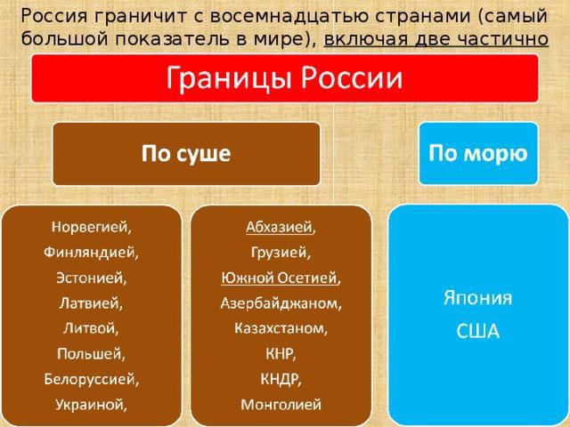
Russia recognizes the existence of borders with 18 states: Norway, Finland, Estonia, Latvia, Lithuania, Poland, Belarus, Ukraine, Georgia, Azerbaijan, Kazakhstan, China, Mongolia, North Korea, Japan and the United States, as well as the partially recognized Republic of Abkhazia and South Ossetia. Length Russian border(excluding the annexation of Crimea in 2014) is 60,932 km according to Border Service FSB of the Russian Federation (or 62,269 km according to other data), including 38 thousand km of maritime borders; Among the land borders, 7 thousand km of borders along rivers and 475 km along lakes stand out.
Length
Russia has maritime boundaries of exclusive economic zones (EEZ) in the Barents Sea, Chukchi, Bering, Okhotsk, Japan, Azov, Black and Baltic seas with the following countries: Norway, USA, Japan, North Korea, Abkhazia, Turkey, Ukraine, Poland, Sweden, Lithuania, Estonia, Finland. According to Federal law dated December 17, 1998 No. 191-FZ “On the Exclusive Economic Zone of the Russian Federation” and the corresponding UN Convention on the Law of the Sea of 1982, the internal border of the exclusive economic zone of the Russian Federation is the external border of the territorial sea (territorial waters), and the external border of the EEZ is located at a distance of 200 nautical miles (370.4 km) from the baselines from which the breadth of the territorial sea is measured.
In the northeastern part of Eurasia there is a country occupying 31.5 percent of its territory - Russia. She has huge number sovereign neighbors. Today, Russia's borders are impressively long. 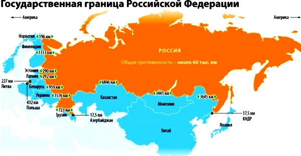
The Russian Federation is unique in that, being located simultaneously in Asia and Europe, it occupies the northern part of the first and the eastern expanses of the second.
Map of the southern border of the Russian Federation indicating all neighboring states
It is well known that the length of Russia’s borders is 60.9 thousand km. The land borders are 7.6 thousand km. Russia's maritime borders have a length of 38.8 thousand km.
What you need to know about the Russian state border
In accordance with the provisions of international law, the state border of Russia is defined as the surface globe. It includes both territorial waters and internal waters. In addition, the “composition” of the state border includes the bowels of the earth and airspace.
The state border of Russia is the existing water and territorial line. The main “function” of the state border should be considered the determination of current territorial limits.
Types of state borders
After the collapse of the great and mighty Soviet Union, in the Russian Federation there are the following types borders:
- old (these borders were “inherited” by Russia from the Soviet Union);
- new.
A similar map of the borders of the USSR indicating the borders of the republics of the union
Old borders include those that coincide with the borders of states that were once full members of one big Soviet family. Most of the old borders are fixed by contracts concluded in accordance with current international standards. Such states should be considered as relatively close to Russia and , so and .
Experts include those that border the Baltic countries, as well as the states of the CIS, as new borders. The latter, first of all, should include.
Soviet times It’s not for nothing that they drive patriotic-minded citizens of the older generation into nostalgia. The fact is that after the collapse of the Soviet Union, Russia lost more than 40 percent of its equipped border.
"Extirpated" boundaries
It is not for nothing that Russia is called a unique state. It has borders that are defined today as “extended” zones to the borders of the former Soviet Union.  Russia today has many problems with borders. They became especially acute after the collapse of the Soviet Union. On geographical map everything looks quite nice. But in reality, the new borders of Russia have nothing in common with cultural and ethnic borders. Another significant problem is the categorical rejection public opinion restrictions that arose in connection with the introduction of border posts.
There's another one serious problem. After the collapse of the Soviet Union, the Russian Federation was unable to equip its new borders in a timely manner technically. Today, the solution to the problem is moving forward, but not fast enough.
Given the serious danger looming from some former Soviet republics, this issue remains at the forefront. The southern and western borders are predominantly land. East and north refer to water boundaries.
Map of the collapse of the Soviet Union
What you need to know about the key borders of the Russian Federation
By 2019, our country will have large number neighbors. On land, our country borders on fourteen powers. It is important to note all neighbors:
- Republic of Kazakhstan.
- Mongolian state.
- Belarus.
- Polish Republic.
- Republic of Estonia.
- Norway.
Our country also has borders with the Abkhaz state and South Ossetia. But these countries are still not recognized by the “international community,” which still considers them part of the Georgian state.
Map of the Russian border with Georgia and the unrecognized republics
For this reason, the borders of the Russian Federation with these small states are not generally recognized in 2019.
Who does the Russian Federation border on land?
The most important land neighbors of the Russian Federation include the Norwegian state. The border with this Scandinavian state runs along the swampy tundra from Varanger Fjord. Here are the important power stations domestic and Norwegian production.
Today on top level The issue of creating a transport route to this country, cooperation with which began in the deep Middle Ages, is being seriously discussed.
A little further south lies the border with the Finnish state. The terrain here is wooded and rocky. This area is important for Russia for the reason that it is here that active foreign trade. Finnish cargo is transported to the port of Vyborg from Finland. The western border of the Russian Federation stretches from the Baltic waters to the Sea of Azov.
Map of Russia's western border showing all border states
The first section should include the border with the Baltic powers. The second section, no less important, is the border with Belarus. In 2019, it continues to remain free for the transport of goods and the travel of people. The European transport route passes through this section, having great importance for Russia. Not long ago, a historic decision was made regarding the creation of a new powerful gas pipeline. The main point is considered to be the Yamal Peninsula. The highway will pass through Belarus to Western European countries.
Ukraine is not only geopolitically, but also geographically important for Russia. Considering difficult situation, which continues to remain extremely tense in 2019, the Russian authorities are doing everything possible to lay new railway tracks. But railway, connecting Zlatoglavaya with Kiev still does not lose its relevance.
Who does the Russian Federation border on the sea?
Our most important water neighbors include Japan and the United States of America.
Map of the maritime borders of the Russian Federation
Both of these states are separated from the Russian Federation by small straits. The Russian-Japanese border is designated between Sakhalin, the South Kuril Islands and Hokkaido.
After the annexation of Crimea, Russia also had neighbors in the Black Sea. Such countries include Turkey, Georgia and Bulgaria. The oceanic neighbors of the Russian Federation include Canada, located on the other side of the Arctic Ocean.
The most important Russian ports include:
- Arkhangelsk
- Murmansk.
- Sevastopol.
The great Northern Route begins from Arkhangelsk and Murmansk. Most of the waters there are covered with a huge crust of ice for eight to nine months. In 2016, by order of the President of the Russian Federation, preparations began for the creation of an underwater Arctic highway. It is assumed that this route will use nuclear submarines to transport important cargo. Of course, only submarines that have been decommissioned will take part in the transportation.
Disputed areas
In 2019, Russia still has some unresolved geographic disputes. Today the following countries are involved in the “geographical conflict”:
- Republic of Estonia.
- Republic of Latvia.
- People's Republic of China.
- Japan.
If we take into account that the so-called “international community” denies the annexation of Crimea to Russia, ignoring the results of the referendum held in March 2014, then Ukraine should be added to this list. In addition, Ukraine seriously lays claim to some Kuban lands.
The issue of Transnistria, also important for our country, is being resolved to a greater extent with the Moldavian Republic. Some experts believe that the “Crimean issue” is also relevant for Turkey. The dispute continues regarding South Ossetia and Abkhazia. But these countries are not part of the Russian Federation, so this issue is considered from a different perspective.
Disputed section of the Russian-Norway border
The so-called “Arctic issue” in the near future, it seems, will only be a method of “subtle trolling” for some of Russia’s maritime neighbors.
Claims of the Republic of Estonia
This issue is not discussed as diligently as the “Kuril Islands problem.” And the Republic of Estonia lays claim to the right bank of the Narva River, which is located on the territory of Ivangorod. Also, the “appetites” of this state extend to the Pskov region.
Five years ago, an agreement was concluded between the Russian and Estonian states. It outlined the delimitation of water spaces in the Gulf of Finland and Narva Gulf.
The “main hero” of Russian-Estonian negotiations is considered to be “Saatse’s Boot”. It is in this place that bricks are transported from the Urals to European countries. Once upon a time they wanted to transfer the “boot” to the Estonian state in exchange for other parts of the land. But due to significant amendments made by the Estonian side, our country did not ratify the agreement.
Claims of the Republic of Latvia
Until 2007, the Republic of Latvia wanted to obtain the territory of the Pytalovsky district, which is located in the Pskov region. But in March an agreement was signed according to which this area should remain the property of our country.
What China wanted and what it achieved
Five years ago, the demarcation of the Chinese-Russian border was carried out. According to this treaty, the People's Republic of China received land plot in the Chita region and 2 plots near the Bolshoy Ussuriysky and Tarabarov islands.
In 2019, a dispute continues between our country and China regarding the Republic of Tuva. In turn, Russia does not recognize Taiwan's independence. There are no diplomatic relations with this state. Some seriously fear that the People's Republic of China is interested in dividing Siberia. This issue has not yet been discussed at the highest level, and dark rumors are very difficult to comment on and analyze.
China-Russia border map
2015 shows that there should not be any serious geographic friction between Russia and China in the near future.
Maritime disputed areas
The “maritime” dispute between Russia and Ukraine once concerned not only Azov, but also the Bosporus Strait. The site includes the Tuzla Spit, which was the subject of fierce diplomatic battles before the 2014 referendum. It is important to understand that the Tuzla braid is not of particular value. This is a small piece of land, favored by Kerch and Temryuk fishermen. Today the Tuzla issue is still discussed. But not with the Ukrainian side, but with the specialists leading the construction of the Kerch Bridge.
There was once a serious dispute between Russia, Kazakhstan, Azerbaijan and Turkmenistan regarding the division of the Caspian Sea. In 2003, an agreement concluded between all parties to the dispute was finally signed. According to this agreement, the Caspian Sea is partially divided along the median line.
Russia is the largest country in the world in terms of territory, which accounts for 1/7 of the entire landmass. Canada, which is in second place, is almost twice as big as us. What about the length of Russia's borders? What is she like?
Longer than the equator
The borders of Russia stretch from Pacific Ocean through all the marginal seas of the Arctic Ocean in the north, through the Amur, many kilometers of steppes and the Caucasus mountains in the south. In the west they extend across the East European Plain and Finnish marshes.
According to data for 2014 (excluding the annexation of the Crimean Peninsula), the total length of Russia’s borders is 60,932 km: land borders extend for 22,125 km (including 7,616 km along rivers and lakes) and sea borders for 38,807 km.
Neighbours
Russia also holds the record among countries with the largest number of border states. The Russian Federation neighbors 18 countries: in the west - with Finland, Estonia, Lithuania, Latvia, Poland, Belarus and Ukraine; in the south - with Georgia, Azerbaijan, Kazakhstan, China, Mongolia and the DPRK; in the east - with Japan and the USA.
Border State | Length of land border, including river and lake borders (km) | Length of land border only (km) |
Norway | ||
Finland | ||
Belarus | ||
Azerbaijan | ||
South Ossetia | ||
Kazakhstan | ||
Mongolia | ||
North Korea | ||
The length of Russia's maritime borders is about 38,807 km, including sections along the oceans and seas:
- Arctic Ocean - 19724.1 km;
- Pacific Ocean - 16997.9 km;
- Caspian Sea - 580 km;
- Black Sea - 389.5 km;
- Baltic Sea - 126.1 km.
History of territory changes
How has the length of the Russian border changed? By 1914, the extent of the territory Russian Empire amounted to 4675.9 km in the direction from north to south and 10732.4 km from west to east. At that time, the total length of the borders was 69,245 km: of which 49,360.4 km were sea borders, and 19,941.5 km were land borders. At that time, the territory of Russia was 2 million km 2 larger than the modern area of the country.
During the times of the USSR, the area of the union state reached 22,402 million km 2. The country stretched for 10,000 km from west to east and 5,000 km from north to south. The length of the borders at that time was the largest in the world and amounted to 62,710 km. After the collapse of the USSR, Russia lost about 40% of its territories.
The length of the Russian border in the north
Its northern part runs along the coast of the Arctic Ocean. The Russian sector of the Arctic is limited by conditional lines running in the west from the Rybachy Peninsula and in the east from Ratmanov Island to North Pole. On April 15, 1926, a resolution was adopted by the Central Executive Committee and the Council of People's Commissars on the division of the Arctic into sectors based on the International Concept. It proclaimed the complete right of the USSR to all lands, including islands in the Arctic sector of the USSR.
Southern Frontier
Land border starts from which connects the Black and Azov Seas, passes through the territorial waters of the Black Sea to the Caucasian Psou River. Then it goes mainly along the Great Dividing Range of the Caucasus, then along the Samur River and further to the Caspian Sea. The land demarcation line between Russia, Azerbaijan and Georgia runs in this area. The length of the Caucasian border is more than 1000 km.

There are a huge number of problems in this area. Firstly, there is a conflict between Georgia and Russia over two self-proclaimed republics - South Ossetia and Abkhazia.
Further, the border runs along the periphery of the Caspian Sea. In this area, there is a Russian-Iranian agreement on the division of the Caspian Sea, since during the Soviet era, only these two states divided the Caspian Sea. The Caspian states (Kazakhstan, Azerbaijan and Turkmenistan) demand an equal division of the waters of the Caspian Sea and its shelf, which is rich in oil. Azerbaijan has already started developing fields.
The border with Kazakhstan is the longest - more than 7,500 km. There is still an old inter-republican border between the two states, which was proclaimed in 1922. The question was raised about the transfer to Kazakhstan of parts of the country’s neighboring regions: Astrakhan, Volgograd, Omsk, Orenburg, Kurgan and Altai. Kazakhstan had to cede part of the following territories: North Kazakhstan, Tselinograd, East Kazakhstan, Pavlodar, Semipalatinsk, Ural and Aktobe. From the population census data for 1989 it follows that more than 4.2 million Russians live in the above-mentioned territories of Kazakhstan, and more than 470 thousand Kazakhs live in the mentioned territories of Russia.

The border with China runs along rivers almost everywhere (about 80% of the entire length) and extends for 4,300 km. The western part of the Russian-Chinese border is delimited, but not demarcated. It was only in 1997 that this area was demarcated. As a result, several islands, whose total area is 400 km 2, were left under joint economic management. And in 2005, all the islands within the river waters were demarcated. Claims to certain areas of Russian territory were presented in their maximum volume in the early 1960s. They included all Far East and Siberia.

In the southeast, Russia neighbors the DPRK. The entire border runs along the Tumannaya River, stretching only 17 km. Further along the river valley it reaches the shores of the Sea of Japan.
Western Frontier
Almost along its entire length, the border has a clear expression of natural boundaries. It originates from the Barents Sea and extends to the Pasvik River valley. The length of Russia's land borders in this territory is 200 km. A little further south, the border line with Finland stretches 1,300 km through heavily swampy terrain, which stretches to the Gulf of Finland in the Baltic Sea.
The extreme point of the Russian Federation is the Kalingrad region. It neighbors Lithuania and Poland. The total length of this line is 550 km. Most of the border with Lithuania runs along the Nemunas (Neman) River.

From the Gulf of Finland to Taganrog in the Sea of Azov, the border line stretches for 3150 km with four states: Estonia, Latvia, Belarus and Ukraine. The length of the Russian border is:
- with Estonia - 466.8 km;
- with Latvia - 270.6 km;
- with Belarus - 1239 km;
- with Ukraine - 2245.8 km.
Eastern border
Like the northern part of the borders, the eastern part is completely maritime. It extends across the waters of the Pacific Ocean and its seas: Japan, Bering and Okhotsk. The border between Japan and Russia passes through four straits: Sovetsky, Izmena, Kushanirsky and La Perouse. They separate the Russian islands of Sakhalin, Kushanir and Tanfilyev from the Japanese Hokkaido. Japan claims ownership of these islands, but Russia considers them an integral part of itself.

The state border with the United States passes through the Bering Strait through the Diomede Islands. Only 5 km separates the Russian Ratmanov Island from the American Krusenstern. It is the longest maritime border in the world.
The Russian Federation is a huge country, ranking first in the world in terms of area. The states bordering Russia are located from all directions of the world, and the border itself reaches almost 61 thousand km.
Types of borders
The border of a state is the line that limits its actual area. Territory includes areas of land, water, underground minerals and airspace located within a country.
There are 3 types of borders in the Russian Federation: sea, land and lake (river). The sea border is the longest of all, it reaches about 39 thousand km. The land border is 14.5 thousand km long, and the lake (river) border is 7.7 thousand km long.
General information about all states bordering the Russian Federation
Which states does the Federation recognize its neighborhood with? 18 countries.
Name of states bordering Russia: South Ossetia, Republic of Belarus, Republic of Abkhazia, Ukraine, Poland, Finland, Estonia, Norway, Latvia, Lithuania, Kazakhstan, Georgia, Azerbaijan, United States of America, Japan, Mongolia, China First order countries are listed here .
Capitals of states bordering Russia: Tskhinvali, Minsk, Sukhum, Kyiv, Warsaw, Oslo, Helsinki, Tallinn, Vilnius, Riga, Astana, Tbilisi, Baku, Washington, Tokyo, Ulaanbaatar, Beijing, Pyongyang.
South Ossetia and the Republic of Abkhazia are partially recognized because not all countries in the world have recognized these countries as independent. Russia did this in relation to these states, therefore, it approved the neighborhood and borders with them.
Some states bordering Russia argue about the correctness of these borders. For the most part, disagreements arose after the end of the USSR.

Land borders of the Russian Federation
The states bordering Russia by land are located on the Eurasian continent. These also include lake (river) ones. Not all of them are currently protected; some of them can be easily crossed with only a passport of a citizen of the Russian Federation, which is not always available mandatory is being checked.
States bordering Russia on the mainland: Norway, Finland, Belarus, South Ossetia, Ukraine, Republic of Abkhazia, Poland, Lithuania, Estonia, Kazakhstan, Latvia, Georgia, Azeybardzhan, Mongolia, People's Republic of China, North Korea.
Some of them also have a water border.
Available Russian territories which are surrounded on all sides foreign countries. Such areas include the Kaliningrad region, Medvezhye-Sankovo and Dubki.
You can travel to the Republic of Belarus without a passport and any border control along any of the possible roads.
Maritime borders of the Russian Federation
Which states does Russia border by sea? The sea border is considered to be a line 22 km or 12 nautical miles from the coast. The country's territory includes not only 22 km of water, but also all the islands in this sea area.
States bordering Russia by sea: Japan, the United States of America, Norway, Estonia, Finland, Poland, Lithuania, Abkhazia, Azerbaijan, Kazakhstan, Ukraine, North Korea. There are only 12 of them. The length of the borders is more than 38 thousand km. Russia has only a maritime border with the USA and Japan; there is no land boundary line with these countries. There are borders with other states both by water and by land.

Settled disputed sections of the border
At all times, there have been disputes between countries over territories. Some of the disputing countries have already agreed and are no longer raising this issue. These include: Latvia, Estonia, People's Republic of China and Azerbaijan.
The dispute between the Russian Federation and Azerbaijan occurred over a hydroelectric complex and water intake structures that belonged to Azerbaijan, but were in fact located in Russia. In 2010, the dispute was resolved, and the border was moved to the middle of this waterworks. Now water resources The countries use this hydroelectric system in equal shares.
After the collapse of the USSR, Estonia considered it unfair that the right bank of the Narva River, Ivangorod and the Pechora region remained the property of Russia (Pskov region). In 2014, the countries signed an agreement on the absence of territorial claims. The border did not suffer any noticeable changes.

Latvia, like Estonia, began to lay claim to one of the districts of the Pskov region - Pytalovsky. An agreement with this state was signed in 2007. The territory remained the property of the Russian Federation, the border did not change.
The dispute between China and Russia ended with the demarcation of the border along the center of the Amur River, which led to the annexation of the Chinese People's Republic parts of the disputed territories. The Russian Federation transferred 337 square kilometers to its southern neighbor, including two plots in the Tarabarov region and one plot near Bolshoy Island. The signing of the agreement took place in 2005.
Unsettled disputed sections of the border
Some disputes over territory are not closed to this day. It is not yet known when the agreements will be signed. Russia has such disputes with Japan and Ukraine.
The disputed territory between Ukraine and the Russian Federation is Crimean peninsula. Ukraine considers the 2014 referendum illegal and Crimea occupied. The Russian Federation established its border unilaterally, while Ukraine passed a law creating a free economic zone on the peninsula.
The dispute between Russia and Japan is over the four Kuril Islands. The countries cannot come to a compromise because both believe that these islands should belong to them. These islands include Iturup, Kunashir, Shikotan and Habomai.
Boundaries of exclusive economic zones of the Russian Federation
An exclusive economic zone is a strip of water adjacent to the border of the territorial sea. It cannot be wider than 370 km. In this zone, the country has the right to develop subsoil resources, as well as to explore them and preserve them, to create artificial structures and their use for the study of water and the bottom.
Other countries have the right to move freely through this territory, install pipelines and otherwise use this water, but they must take into account the laws of the riparian state. Russia has such zones in the Black, Chukchi, Azov, Okhotsk, Japanese, Baltic, Bering and Barents seas.
The Russian Federation is the largest state on the planet. Its area is estimated at millions of square kilometers. Which countries border Russia? And what are the peculiarities of the geopolitical position of this country? About this we'll talk in this article.
Which countries border Russia?
Russia is the leading country on the planet in terms of size. Its area is just over 17 million square kilometers. True, only 146 million people live on such a vast territory, so the average population density in the country is low (8.4 people per square kilometer of area). How many countries does Russia border with?
If we take into account all countries, including those partially recognized by the international community ( we're talking about about Abkhazia and South Ossetia), then Russia is the world leader in the number of neighboring countries. There are 16 of them in total.
Which countries border Russia? These are Norway, Finland, Latvia, Lithuania, Estonia, Poland, Ukraine, Georgia, Azerbaijan, Belarus, Kazakhstan, China, Mongolia, North Korea, as well as South Ossetia and Abkhazia. Russia borders on two more countries by sea: Japan and the USA.
Features of the geopolitical situation of modern Russia
Geopolitical models view Russia as a major player surrounded by so-called large spheres (according to Cohen). In the west there is a bloc of NATO countries, which is moving closer and closer to the state borders of the Russian Federation. By the beginning of the 21st century, this bloc had completely extended its influence to the Balkan Peninsula, the Baltic states and Eastern Europe. In the south, Russia borders on another powerful player - China, which has significant military and economic potential.
If we consider the purely economic aspect of the geopolitical situation, then Russia is surrounded on all sides by members of the so-called economic Triad of the planet. These are the European Union in the west (about 20% of world GDP), Japan in the east (9%) and China in the south (18%).

Let us consider in more detail the western, southern and eastern sectors of the Russian state border.
Western borders of Russia
Russia's western border begins on the coast Barents Sea and practically does not encounter natural boundaries on its way. Which countries does Russia border on the west? These are six independent states that were previously part of the USSR, as well as two Scandinavian countries (Norway and Finland).
In the west, the longest section of the border is between the Russian Federation and Ukraine (about 1,300 km), and the shortest is with Norway (200 km). It should be noted that there are no border problems or any territorial claims only between Russia and Belarus in this area. Crimea Peninsula - main object dispute with Ukraine, the Pskov region - with Latvia. Norway also lays claim to part of the Barents Sea that belongs to Russia.

Southern borders of Russia
What countries does Russia border on in the south? These are Georgia, Azerbaijan, Kazakhstan, China, Mongolia, as well as two unrecognized republics - South Ossetia and Abkhazia.
The longest section of the Russian border is with Kazakhstan (almost 7,500 kilometers). This line is very arbitrary and practically does not coincide with natural objects (it runs through desert areas or mountain ranges).
Perhaps the most problematic area for Russia is the section of the border in the North Caucasus. There is a whole set of hot spots associated with the unrecognized formations of Abkhazia and South Ossetia.
Eastern borders of Russia
In the east, Russia borders the DPRK by land, as well as Japan and the United States by sea.
The Russian-Korean border is the shortest - only 18 kilometers. It runs entirely along the Tumannaya River. The countries agreed among themselves on the demarcation and delimitation of water areas in the Sea of Japan.

Russia borders two other states in the east solely by sea. The Russian-American maritime border is considered the longest in the world. It should be recalled that Alaska was once sold by Alexander II to the States for seven million dollars.
Serious territorial claims also remain between Russia and Japan. The object of the dispute is a number of islands of the Kuril chain.
In conclusion...
Now you know which countries border Russia. These are 16 independent states, as well as two partially recognized republics. Unfortunately, problems with the demarcation of many sections of the Russian state border have not yet been resolved. In addition, many neighboring countries make territorial claims against the Russian Federation.